Sunday 28 June 2009

Sources of information about Project Habbakuk

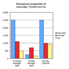
The Wikipedia article on Pykrete cites these properties. While its crushing strength is inferior to concrete, it compares favourably weight-for-weight. It has greater tensile strength, and is far less dense.

Interestingly, it is slightly denser than ice (0.98g/ml, compared with 0.91g/ml for pure ice), and a simple chunk of pykrete would float far lower in cold water than a similar-sized chunk of ice. I should be able to confirm this with my own samples, using the Archimedes principle.

Polymer scientist Herman Mark was the first to propose using wood pulp to strengthen ice, and describes the proposal in his 1993 autobiography, From Small Organic Molecules to Large.

Max Perutz published this schematic diagram of the bergship and described further properties of pykrete in his 1948 paper, A Description of The Iceberg Aircraft Carrier, in The Journal of Glaciology, volume I. In my next post, I shall discuss data from this paper.

Perutz discusses his wartime experience and his work on the project in his essay Enemy Alien published in I Wish I'd Made You Angry Earlier and in Is Science Necessary? His biographer, Georgina Ferry, expands further in Max Perutz and the Secret of Life (2007).

J D Bernal
's part in the project is described in two biographies: J.D. Bernal: A Life in Science and Politics by Brenda Swann and Francis Aprahamian, and Andrew Brown's J. D. Bernal: The Sage of Science.

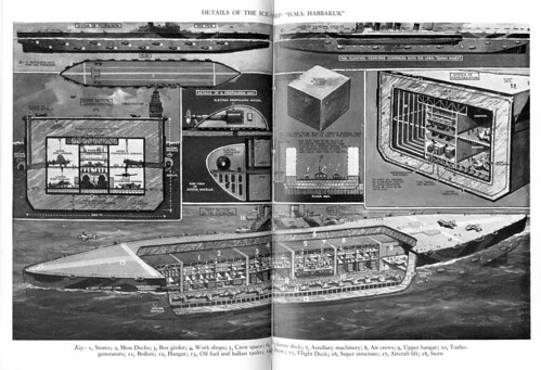
While David Lampe's 1959 biography, Pyke, the Unknown Genius, gives a particularly fanciful account, it does provide this fabulous cutaway diagram of the proposed HMS Habbakuk.


There are apparent discrepancies between the various accounts. I hope to make a trip to Kew to visit the National Archives soon. They have various documents relating to the project, including Adm. Noble's reports on Habakkuk/Tentacle and Proposals and inventions of Mr Geoffrey Pyke; gravity propelled ball bomb, pykrete and power driven rivers which may help to clarify the history. Or else muddy the waters still further with a mush of wood pulp.

Thursday 4 June 2009

The Berg Ship

In future posts, as well as my home experiments, I will delve further into some of the fantastic personalities and myths behind Project Habbakuk, but here’s a brief introduction.

In 1942, the Allies were under attack by Axis forces in the Atlantic. They needed a way to improve the efficacy of their short-range aircraft, and started to look at ways to provide floating platforms to act as aircraft carriers in the North Atlantic.

Projecy Habbakuk was the brainchild of Geoffrey Pyke, an eccentric who had managed to get the ear of Lord Mountbatten and Winston Churchill. He proposed the construction of vast ships made of ice – its natural buoyancy would protect them from sinking in the event of enemy shelling, and the raw material (water) for their repair was virtually free. However, its brittleness and tendency to creep presented difficulties.

Pyke gained scientist J D Bernal’s support to develop the project. Bernal suggested his former student, Max Perutz, who had worked extensively on the properties of ice. Work was slow to start with, until Pyke sent Perutz a paper referring to the reinforcement of ice with microfibres derived from wood pulp. Tests on this material (given the name “Pykrete”, in honour of Geoffrey Pyke) were encouraging, and Perutz was set up in a lab in the cold stores below Smithfield Market in London.
Smithfield Market

Pykrete was dramatically stronger than ice and resistant to melting. Military chiefs were so impressed that they instigated a pilot project to build a model ship in Patricia Lake in Canada. The technical issues were extreme, however, and the cost of machinery needed to freeze the wood pulp and of iron for reinforcement of the bergship negated the cheapness of the raw materials. Furthermore, developments in aircraft design and deals made with the Portuguese to use the Azores for refuelling stations had effectively made the project redundant, and the model ship was scuttled in 1943.

Wednesday 20 May 2009

Beyond the LCC maps – further resources for investigating London’s war

Great though the LCC maps are, they only give us a snapshot of damaged property in 1945. They tell us nothing about when the bombs fell, how many there were, or what kind of bombs. They also tell us nothing about casualty numbers.

But these data were carefully collated throughout the war, and documents in the London Metropolitan Archives and National Archives help to extend our understanding of the period.

The London Metropolitan Archives hold the incident logs kept by local authorities, which detail the number and type of bombs received, and damage and casualties incurred. They were also plotted on bomb census maps, held by the National Archives:

Bomb census 21 10/40 sheet 56/18 NE
Bomb Census Map for South East London, October 1940.

These data were used to estimate density of attacks over the entire London Civil Defence Region - a larger area than the LCC maps cover, roughly corresponding to the Metropolitan Police Area.

This map from the National Archives shows density of bombing in the London region from outbreak of hostilities to October 1941. This shows how heavily the whole of Central London, both north and south of the river was bombarded, alongside dock areas and Chelsea
Density of bombing London region from outbreak of hostilities to October 1941

The National Archives also hold tables of incidents. This table shows incidents by area for 2 weeks during the height of the V1 attacks in summer 1944.
Casualties

The London Civil Defence Region also produced maps of V-weapon strikes. These were widely scattered, but concentrated south of the river. What this map does not show is the number of bombs shot down or falling short of the target in Kent.

Map from the National Archives showing V1 attacks up to 7th August 1944.

fall of fly 15-6-44 to 7-8-44

All these documents are freely accessible to the public at London’s archive centres. Together with the LCC maps, they form a formidable resource for anyone interested in London’s wartime history, helping to provide the chronological framework and document the human cost of the bombing of London.

Wednesday 6 May 2009

My LCC maps on the web

Since I took photos of the LCC maps at the LMA, several people have blogged them or linked to them in local London community forums.

I hope to get on to some more interesting discussion relating to the maps, but firstly, I thought it would be useful to highlight some of these responses to the maps. If you know of any I've missed, I'd love to hear from you.


View V2 rockets on London in a larger map

Londonist - Matt Brown's blogpost and googlemap of V2 strikes (see above) based on my LCC maps set.
5 rocket sites I am near - Neat little application by Tom Taylor, based on Matt Brown's map.
nerviosismo - Related post in Spanish.
Airminded - Pick-up on Londonist's map.
Yorkshire Ranter - Pick-up on Airminded blog.
Transpontine - Post on New Cross Woolworths V2 strike, response to Londonist blog.
Brockley Central Local blog discussing bomb damgae, referring to maps.
SE23.com - Local forum discussion linking to several maps.
Camberwell Online - Local forum discussion linking to relevant maps.
Blackheath Bugle - Local blog on Blitz damage.
hughw36 - Pick-up on Blackheath Bugle blog.
Greenwich Phantom - Local discussion inspired by the Londonist blog... and more in the comment thread on this post about bomb damage at Maze Hill.
London at War - Flickr group discussion.
Pistonheads - Motor forum thread. Their posting rules do not allow me to contribute to the discussion.

Some of these are repetitive and refer back to each other, but I wanted to gather them in one place.

We have also had interesting discussions on the photos within flickr, but these are less formal. I hope to collate some of the gems from those threads in a future post.

[Edited to add references to this blog, 22/05/09]
florizel.canalblog.com - Unfortunately, I'm not sufficiently confident at French to reply.
www.wowblog.co.uk - Response to LCC bomb damage maps post.